
Cart 2 india
In2Cart
Rs. 0
0


Product Information
Specification
Binding : miscellaneous
Brand : Captain Segull's Sportfishing Chart
BulletPoint : Laminated Fishing Chart
BulletPoint1 : Waterproof Charts 221F Estero Bay
BulletPoint2 : Fishing inshore
BulletPoint3 : Manufactured in United States
BulletPoint4 : Meets U. S. and international carriage requirements for commercial vessels
BulletPoint5 : U. S. Coast Guard approved
Color : waterproof lamintated
ExternallyAssignedProductIdentifier1 : 653210102219
ExternallyAssignedProductIdentifier2 : 0653210102219
ExternallyAssignedProductIdentifier3 : 00740399022169
Format : folded_map
ImportDesignation : Made in USA
IncludedComponents : fishing-charts-and-maps
ItemDisplayDimensions_Length : 41.1 inches
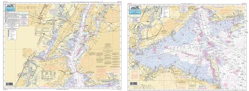
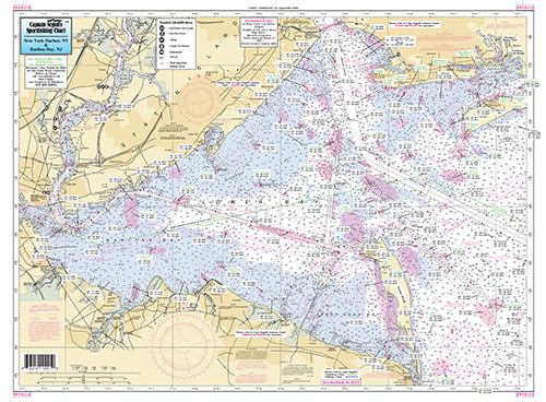
ItemName : Captain Segull's Sportfishing Chart - New York Harbor/Raritan Bay, NY - Laminated Nautical Fishing Chart
ItemPackageDimensions_Height : 32.2 centimeters
ItemPackageDimensions_Length : 0.2 centimeters
ItemPackageDimensions_Width : 16.2 centimeters
ItemPackageQuantity : 1
ItemShape : Rectangle
ItemTypeKeyword : fishing-charts-and-maps
Language : english
Manufacturer : Captain Segull's Nautical Charts, Inc
MapScale : 1:24,000
MapType : Nautical
Material : polypropylene
ModelName : 221F
ModelNumber : 221F
MountingType : Wall Mount
NumberOfItems : 1
NumberOfPieces : 1
Orientation : Landscape
PaintType : Watercolor
PaperFinish : premium_glossy
PaperSize : 19.5 x 26.5 inches
PartNumber : NYH114
ProductDescription : Inshore Fishing Chart: An inshore chart 1-2 miles off the coast detailing the bays. All of NY Harbor to mouth of Hudson River south to Raritan By, NJ Double sided laminated fishing Chart. Shows fishing areas, wrecks, reefs, local names and amenities in GPS out to the thousandths of a minute. 19.5" x 26.5" uses NOAA Chart 12327
ProductSiteLaunchDate : 2016-02-27T21:49:07.887Z
PublicationDate : 2017-08-19T00:00:00.000-07:00
ShipsGlobally : 1
Size : 19.5" x 26.5"
Style : Modern
SupplierDeclaredDgHzRegulation : not_applicable
TargetGender : unisex
TargetSpecies : Mackerel
Theme : Nature
UnitCount : 1
UnspscCode : 55101500