
Cart 2 india
In2Cart
Rs. 0
0


Product Information
Specification
Brand : Captain Segull's Sportfishing Chart
BulletPoint : Laminated Fishing Chart
Color : waterproof laminated
ExternallyAssignedProductIdentifier1 : 0653210104527
ExternallyAssignedProductIdentifier2 : 653210104527
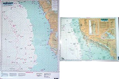
ItemName : East Cape to Naples Bay, FL - Laminated Nautical Navigation & Fishing Chart by Captain Segull's Nautical Sportfishing Charts | Chart # NAP38
ItemPackageQuantity : 1
ItemTypeKeyword : fishing-charts-and-maps
Manufacturer : Captain Segull's Nautical Charts, Inc
PartNumber : NAP38
ProductDescription : Nearshore Fishing Chart: A nearshore chart 20 to 30 miles. Side A, from East Cape to Morman Key. Side B from Morman Key to Clam Pass, includes inset of Naples Bay and Chokoloskee Bay Double sided laminated fishing Chart. Shows fishing areas, wrecks, reefs, local names and amenities in GPS out to the thousandths of a minute. 19.5" x 26.5"
ProductSiteLaunchDate : 2018-11-20T08:00:00.000Z
Size : 19.5" x 26.5"
UnspscCode : 60101700