
Cart 2 india
In2Cart
Rs. 0
0


Product Information
Specification
Brand : Captain Segull's Sportfishing Chart
BulletPoint : Laminated Fishing Chart
Color : waterproof laminated
ExternallyAssignedProductIdentifier1 : 0653210104800
ExternallyAssignedProductIdentifier2 : 653210104800
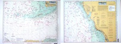
ItemName : Havanah to Tampa, FL - Laminated Nautical Navigation & Fishing Chart by Captain Segull's Nautical Sportfishing Charts | Chart # HTK42
ItemPackageQuantity : 1
ItemTypeKeyword : fishing-charts-and-maps
Manufacturer : Captain Segull's Nautical Charts, Inc
PartNumber : HTK42
ProductDescription : Offshore Fishing Chart: Offshore chart covering 90 to 100 miles out. Side A, south from Havana, Cuba, the Straits of Florida east to Florida Bay, north to Whitewater Bay. Side B, from NW Cape north to Tampa Bay, FL Double sided laminated fishing Chart. Shows fishing areas, wrecks, reefs, local names and amenities in GPS out to the thousandths of a minute. 19.5" x 26.5"
ProductSiteLaunchDate : 2016-02-27T21:48:37.568Z
Size : 19.5" x 26.5"
UnspscCode : 55101500