
Cart 2 india
In2Cart
Rs. 0
0


Product Information
Specification
Binding : miscellaneous
Brand : Captain Segull's Sportfishing Chart
BulletPoint : Laminated Fishing Chart
BulletPoint1 : Spiegel Grove STERN, Key Largo, Florida
BulletPoint2 : Reef Site Card Dive Map of this shipwreck is a waterproof thick plastic card 8 1/2 x 5 1/2 inches with high quality graphics printed on both sides.
BulletPoint3 : Includes site details, depths, currents, GPS coordinates in DDMM.MMM format, distance from nearest port, and other pertinent information which varies by site.
BulletPoint4 : Great planning tool for diving, snorkeling, spearfishing and fishing.
BulletPoint5 : 3-Hole Punched for Log Book or Lanyard when Underwater
Color : double sided
ExternallyAssignedProductIdentifier1 : 0653210102073
ExternallyAssignedProductIdentifier2 : 653210102073
ItemDisplayDimensions_Length : 43.8 inches
ItemDisplayDimensions_Width : 26.5 inches
ItemDisplayWeight : 2 pounds
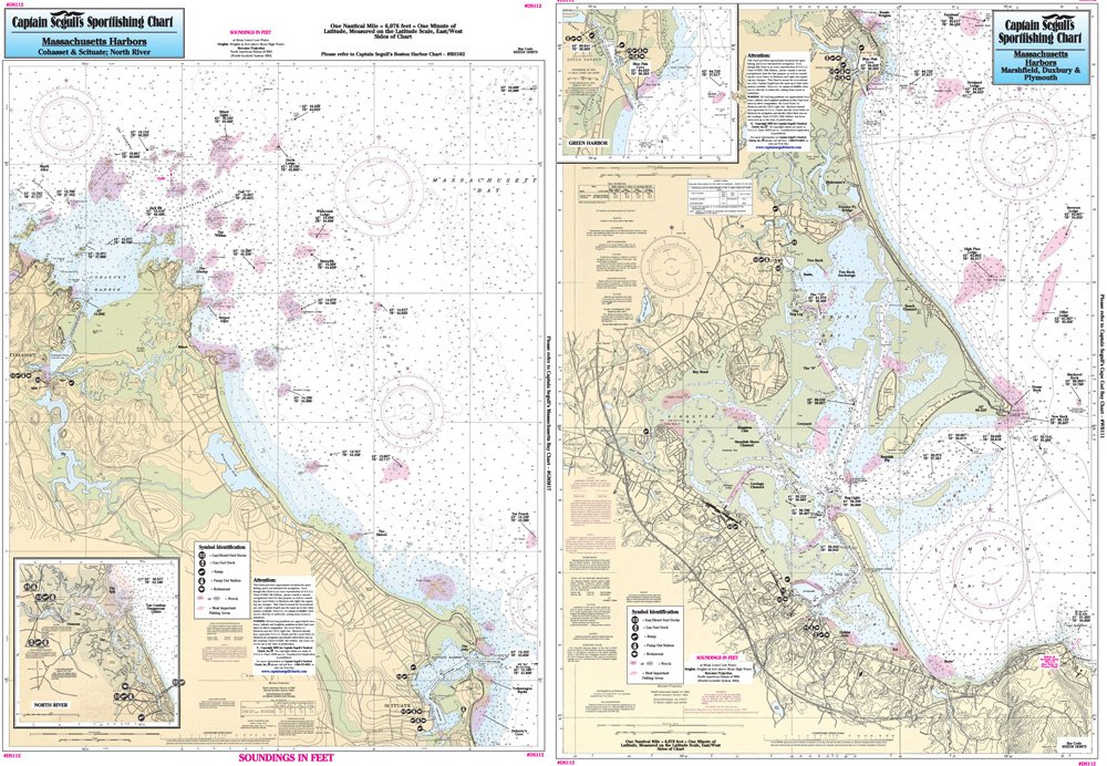
ItemName : Inshore Cohasset to Manomet, MA - Laminated Nautical Navigation & Fishing Chart by Captain Segull's Nautical Sportfishing Charts | Chart # DS112
ItemPackageDimensions_Height : 22.2 centimeters
ItemPackageDimensions_Length : 0.6 centimeters
ItemPackageDimensions_Width : 14.2 centimeters
ItemPackageQuantity : 1
ItemTypeKeyword : fishing-charts-and-maps
Manufacturer : Captain Segull's Nautical Charts, Inc
MapType : Recreation
ModelNumber : MT-14964
NumberOfItems : 1
PaperFinish : smooth
PaperSize : 8.5 x 5.5 inches
PartNumber : DS112
ProductDescription : Inshore Fishing Chart: An inshore chart 1-2 miles off the coast detailing the bays. Side A from Cohasset Harbor to Green Harbor. Side B: from Green Harbor to Manomet. Including Duxbury, Kingston, and Plymouth Bays Double sided laminated fishing Chart. Shows fishing areas, wrecks, reefs, local names and amenities in GPS out to the thousandths of a minute. 19.5" x 26.5"
ProductSiteLaunchDate : 2018-11-20T08:00:00.000Z
ShipsGlobally : 1
Size : 19.5" x 26.5"
Style : 1. Full-Sized Paper Chart - 26.5" x 43.8"
SupplierDeclaredDgHzRegulation : not_applicable
TargetAudience : Unisex Adults
UnitCount : 1
UnspscCode : 60101700