
Cart 2 india
In2Cart
Rs. 0
0


Product Information
Specification
Binding : miscellaneous
Brand : Captain Segull's Sportfishing Chart
BulletPoint : Laminated Fishing Chart
BulletPoint1 : Spiegel Grove STERN, Key Largo, Florida
BulletPoint2 : Reef Site Card Dive Map of this shipwreck is a waterproof thick plastic card 8 1/2 x 5 1/2 inches with high quality graphics printed on both sides.
BulletPoint3 : Includes site details, depths, currents, GPS coordinates in DDMM.MMM format, distance from nearest port, and other pertinent information which varies by site.
BulletPoint4 : Great planning tool for diving, snorkeling, spearfishing and fishing.
BulletPoint5 : 3-Hole Punched for Log Book or Lanyard when Underwater
Color : laminated waterproof
ExternallyAssignedProductIdentifier1 : 0653210102141
ExternallyAssignedProductIdentifier2 : 653210102141
ItemDisplayDimensions_Length : 43.8 inches
ItemDisplayDimensions_Width : 26.5 inches
ItemDisplayWeight : 2 pounds
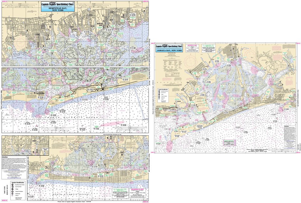
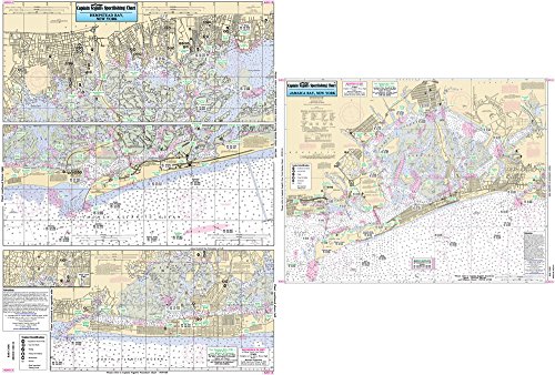
ItemName : Inshore Jamaica and Hempstead Bays, NY - Laminated Nautical Navigation & Fishing Chart by Captain Segull's Nautical Sportfishing Charts | Chart # JH113
ItemPackageDimensions_Height : 22.2 centimeters
ItemPackageDimensions_Length : 0.6 centimeters
ItemPackageDimensions_Width : 14.2 centimeters
ItemPackageQuantity : 1
ItemTypeKeyword : fishing-charts-and-maps
Manufacturer : Captain Segull's Nautical Charts, Inc
MapType : Recreation
ModelNumber : MT-14964
NumberOfItems : 1
PaperFinish : smooth
PaperSize : 8.5 x 5.5 inches
PartNumber : JH113
ProductDescription : Inshore Fishing Chart: An inshore chart 1-2 miles off the coast detailing the bays. Hempstead Bay to Jones Inlet to East Rockaway Inlet; Jamaica Bay & Rockaway Inlet to Sheepshead Bay Double sided laminated fishing Chart. Shows fishing areas, wrecks, reefs, local names and amenities in GPS out to the thousandths of a minute. 19.5" x 26.5"
ProductSiteLaunchDate : 2016-02-27T21:49:05.400Z
ShipsGlobally : 1
Size : 19.5" x 26.5"
Style : 1. Full-Sized Paper Chart - 26.5" x 43.8"
SupplierDeclaredDgHzRegulation : not_applicable
TargetAudience : Unisex Adults
UnitCount : 1
UnspscCode : 55101500