
Cart 2 india
In2Cart
Rs. 0
0


Product Information
Specification
Binding : map
Brand : Captain Segull's Sportfishing Chart
BulletPoint : Laminated Fishing Chart
BulletPoint1 : Size: 31.18 inches high by 42.69 inches wide.
BulletPoint2 : Printed on 46 pound paper
BulletPoint3 : Always printed to order to include all changes upto date of order.
BulletPoint4 : Meets U.S. and international carriage requirements for commercial vessels.
BulletPoint5 : U. S. Coast Guard approved
Color : double sided
ExternallyAssignedProductIdentifier1 : 0653210105012
ExternallyAssignedProductIdentifier2 : 653210105012
Format : folded_map
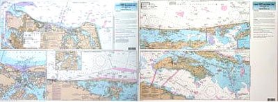
ItemName : Inshore Norfolk, VA to Oregon Inlet, NC - Laminated Nautical Navigation & Fishing Chart by Captain Segull's Nautical Sportfishing Charts | Chart # CHO123
ItemPackageDimensions_Height : 4 inches
ItemPackageDimensions_Length : 36 inches
ItemPackageDimensions_Width : 4 inches
ItemPackageQuantity : 1
ItemTypeKeyword : fishing-charts-and-maps
Language : english
Language1 : english
Language2 : english
Language3 : english
Language4 : english
Language5 : english
Manufacturer : Captain Segull's Nautical Charts, Inc
MapScale : 1:280000
MapType : Recreation
MapType1 : Freshwater
MapType2 : Freshwater
MapType3 : Freshwater
MapType4 : Freshwater
MapType5 : Freshwater
ModelNumber : MT-13233
PaperFinish : premium_glossy
PaperSize : 12x54 inches
PartNumber : CHO123
ProductDescription : Inshore Fishing Chart: An inshore chart from, side A, Norfolk, VA to Knotts Island, NC with an inset of Lynnhaven Bay, side B, Currituck Sound to Pea Island, NC, including Croatan Sound and Currituck Sound Shows fishing areas, wrecks, reefs, local names and amenities in GPS out to the thousandths of a minute. 19.5" x 26.5"
ProductSiteLaunchDate : 2018-11-20T08:00:00.000Z
PublicationDate : 2022-01-01T00:00:00.000-08:00
ShipsGlobally : 1
Size : 19.5" x 26.5"
SupplierDeclaredDgHzRegulation : not_applicable
SupplierDeclaredDgHzRegulation1 : not_applicable
SupplierDeclaredDgHzRegulation2 : not_applicable
SupplierDeclaredDgHzRegulation3 : not_applicable
SupplierDeclaredDgHzRegulation4 : not_applicable
SupplierDeclaredDgHzRegulation5 : not_applicable
UnspscCode : 55101500