
Cart 2 india
In2Cart
Rs. 0
0


Product Information
Specification
Brand : Captain Segull's Sportfishing Chart
BulletPoint : Laminated Fishing Chart
BulletPoint1 : Printed on high quality waterproof and tear-resistant material
BulletPoint2 : Always printed on demand using the most recent NOAA data
BulletPoint3 : Prepared to be display quality. Arrives rolled, not folded.
BulletPoint4 : Small Format charts DO NOT satisfy USCG CARRIAGE REQUIREMENTS
Color : waterproof laminated
ExternallyAssignedProductIdentifier1 : 0653210101199
ExternallyAssignedProductIdentifier2 : 653210101199
ExternallyAssignedProductIdentifier3 : 00740399013259
Hazmat : auto-grounding
ImportDesignation : Made in USA
IncludedComponents : fishing-charts-and-maps
ItemDisplayDimensions_Length : 43.6 inches
ItemDisplayDimensions_Width : 35.5 inches
ItemDisplayWeight : 2 pounds
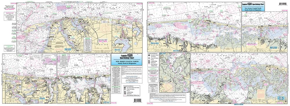
ItemName : Inshore North Coast of New Jersey - Laminated Nautical Navigation & Fishing Chart by Captain Segull's Nautical Sportfishing Charts | Chart # NNJ109
ItemPackageDimensions_Height : 1 inches
ItemPackageDimensions_Length : 13.8 inches
ItemPackageDimensions_Width : 7 inches
ItemPackageQuantity : 1
ItemShape : Rectangle
ItemTypeKeyword : fishing-charts-and-maps
Manufacturer : Captain Segull's Nautical Charts, Inc
Material : Polypropylene
ModelName : 132E
ModelNumber : 132E
NumberOfItems : 1
PartNumber : NNJ109
ProductDescription : Inshore Fishing Chart: An inshore chart 1-2 miles off the coast detailing the bays. New Jersey Coast from Sandy Hook to Brigantine, including Barnegat Bay sDouble sided laminated fishing Chart. Shows fishing areas, wrecks, reefs, local names and amenities in GPS out to the thousandths of a minute. 19.5" x 26.5" Uses NOAA Charts 12324 & 12316
ProductSiteLaunchDate : 2016-02-27T21:49:01.435Z
Size : 19.5" x 26.5"
Style : Small Format
UnspscCode : 55101500