
Cart 2 india
In2Cart
Rs. 0
0


Product Information
Specification
Binding : map
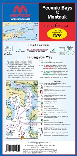
Brand : MAPTECH
BulletPoint : Laminated Fishing Chart
BulletPoint1 : Waterproof Design: High-quality, waterproof, synthetic paper ensures durability and protection against water damage.
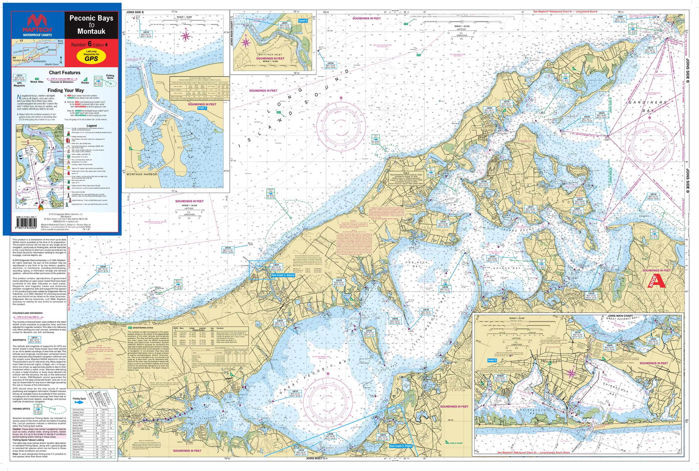
BulletPoint2 : Comprehensive Coverage: Includes detailed maps of Buzzards Bay, Vineyard Sound, and the South Shore of Cape Cod, with GPS waypoints for major buoys, courses, distances, wreck sites, and ramp locations.
BulletPoint3 : User-Friendly Format: Flip-Fold format allows for easy handling and storage, measuring 24" x 36" when open and 6" x 12" when folded.
BulletPoint4 : Detailed Scales: scale 1:50,000, with insets for added detail.
BulletPoint5 : Portable Size: Compact folded dimensions of 6" x 12" make it easy to carry and store.
Color : Chart yellow, blue, green, black, red
ExternallyAssignedProductIdentifier1 : 0743612051
ExternallyAssignedProductIdentifier2 : 9780743612050
Format : unknown_format
ItemName : MAPTECH Waterproof Chart, Peconic Bays to Montauk, 4th Edition, 24 x 36 inches Open, 6 x 12 inches Folded, 1:50,000 Scale, Synthetic Paper
ItemPackageDimensions_Height : 4 inches
ItemPackageDimensions_Length : 36 inches
ItemPackageDimensions_Width : 4 inches
ItemPackageQuantity : 1
ItemTypeKeyword : fishing-charts-and-maps
Language : english
Language1 : english
Language2 : english
Language3 : english
Language4 : english
Language5 : english
Manufacturer : MAPTECH®
MapScale : scale 1:50,000
MapType : Recreation
MapType1 : Freshwater
MapType2 : Freshwater
MapType3 : Freshwater
MapType4 : Freshwater
MapType5 : Freshwater
ModelNumber : MT-13233
PaperFinish : premium_glossy
PaperSize : 12x54 inches
PartNumber : WPC006-04
ProductDescription : The MAPTECH Waterproof Chart WPC006-04, Peconic Bay to Montauk is an indispensable tool for navigating the waters around Montauk. This 4th edition chart provides highly detailed coverage of Peconic Bay making it a must-have for boaters and sailors exploring the region. The user-friendly, flip-fold format measures 24 inches x 36 inches when open and a compact 6 inches x 12 inches when folded, making it easy to store and reference on board. With scales of 1:53,333 and 1:57,140, and insets for added detail, this chart offers precise and comprehensive information. It features GPS waypoints for major buoys, courses and distances, wreck sites, and ramp locations and information, ensuring safe and efficient navigation. Printed on high-quality, waterproof synthetic paper, this chart is designed to withstand the elements, ensuring its longevity and reliability on the water. Whether you're an experienced mariner or a recreational boater, the MAPTECH Waterproog chart Peconic Bay is an essential tool for exploring the stunning coastal waters of Montauk.
ProductSiteLaunchDate : 2024-06-11T14:01:41.404Z
PublicationDate : 2019T
ShipsGlobally : 1
Size : 19.5" x 26.5"
SupplierDeclaredDgHzRegulation : not_applicable
SupplierDeclaredDgHzRegulation1 : not_applicable
SupplierDeclaredDgHzRegulation2 : not_applicable
SupplierDeclaredDgHzRegulation3 : not_applicable
SupplierDeclaredDgHzRegulation4 : not_applicable
SupplierDeclaredDgHzRegulation5 : not_applicable
UnspscCode : 14111500