
Cart 2 india
In2Cart
Rs. 0
0


Product Information
Specification
Binding : map
Brand : Captain Segull's Sportfishing Chart
BulletPoint : Laminated Fishing Chart
BulletPoint1 : OceanGrafix provides mariners with the most up-to-date, NOAA-approved nautical charts ever offered
BulletPoint2 : Charts are printed only after an order has been received, ensuring the most up-to-date information
BulletPoint3 : All Notice to Mariners corrections are applied
BulletPoint4 : Meets U. S. and international carriage requirements for commercial vessels
BulletPoint5 : U. S. Coast Guard approved
Color : waterproof laminated
ExternallyAssignedProductIdentifier1 : 0653210106484
ExternallyAssignedProductIdentifier2 : 653210106484
Format : folded_map
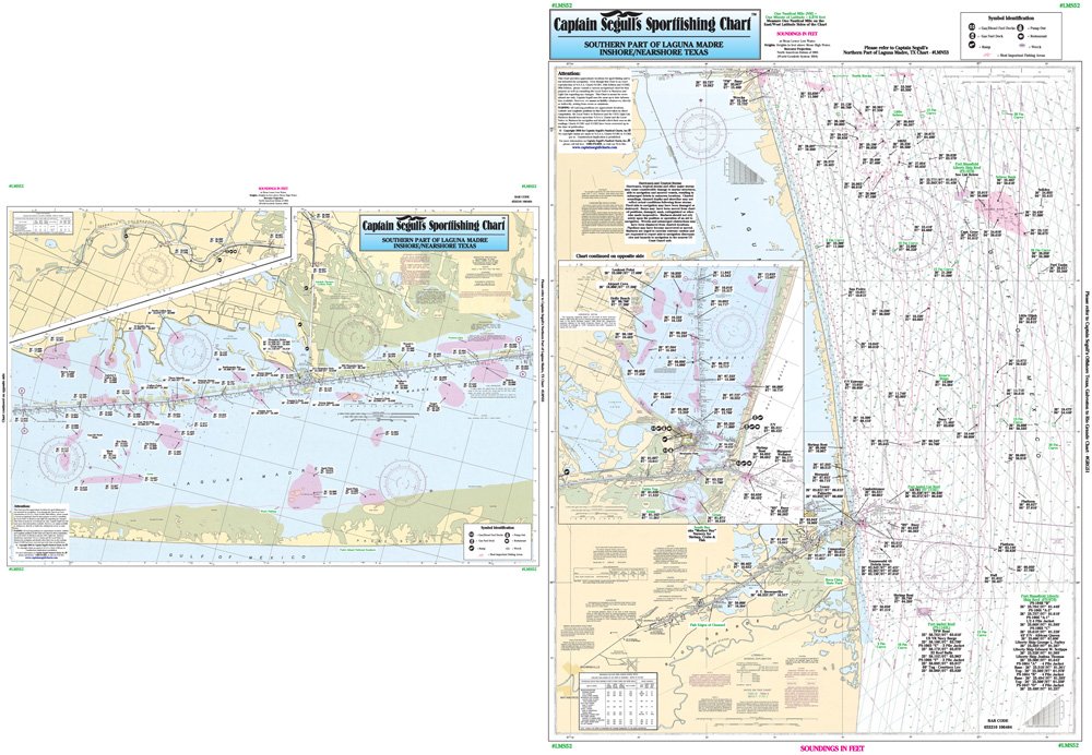
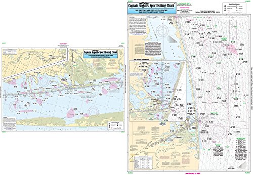
ItemName : Nearshore/Inshore Laguna Madre South, TX - Laminated Nautical Navigation & Fishing Chart by Captain Segull's Nautical Sportfishing Charts | Chart # LMS52
ItemPackageDimensions_Height : 4 inches
ItemPackageDimensions_Length : 36 inches
ItemPackageDimensions_Width : 4 inches
ItemPackageQuantity : 1
ItemShape : Rectangle
ItemTypeKeyword : fishing-charts-and-maps
Language : english
Manufacturer : Captain Segull's Nautical Charts, Inc
MapScale : 1:24,000
MapType : Navigational
Material : Polypropylene
ModelNumber : MT-18645
PaperFinish : premium_glossy
PaperFinish1 : matte
PaperFinish2 : smooth
PaperSize : 35 x 46 inches
PartNumber : LMS52
ProductDescription : Inshore/Nearshore Fishing Chart: Side A: Nearshore chart from Rio Grande to the Port Mansfield channel, with inset of Port Isabel Area. Side B: Inshore/ICW chart from Stover Point to Chubby Island, with inset of the Arroyo Colorado shows loads of local fishing areas with local names and GPS coordinates 19.5" x 26.5"
ProductSiteLaunchDate : 2018-11-20T08:00:00.000Z
PublicationDate : 2017-10-09T00:00:00.000-07:00
ShipsGlobally : 1
Size : 19.5" x 26.5"
SubjectKeyword : 'non-fiction', 'sport'
SupplierDeclaredDgHzRegulation : not_applicable
UnspscCode : 60101700