
Cart 2 india
In2Cart
Rs. 0
0


Product Information
Specification
Binding : map
Brand : East View Map Link
BulletPoint : 12" x 18"
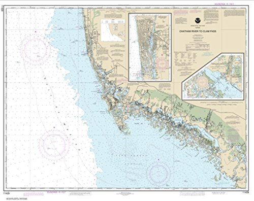
BulletPoint1 : NOAA-OCS cancelled Raster and PDF chart 11429- Chatham River to Clam Pass;Naples Bay;Everglades Harbor Edition #24 on January 4, 2023. The product will NOT meet U. S. and international carriage requirements for commercial vessels defined in SOLAS Chapter V Regulation 19.2.1.
BulletPoint2 : Printed on PaperTyger, a lightweight, tear-resistant, water-resistant paper with a smooth matte paper feel.
BulletPoint3 : Printed by East View Geospatial. Map scale: 1:80,000. Map size (inches): 88 x 111.
BulletPoint4 : Pre-production finishing for superior quality.
BulletPoint5 : Split rings and hooks for clipping to waders or a boat
Color : full color
ExternallyAssignedProductIdentifier1 : 0653210114304
ExternallyAssignedProductIdentifier2 : 653210114304
Format : folded_map
ItemName : NOAA Chart 11429-Chatham River to Clam Pass; Naples Bay; Everglades Harbor - Water-Resistant - by East View Geospatial
ItemPackageDimensions_Height : 4 inches
ItemPackageDimensions_Length : 36 inches
ItemPackageDimensions_Width : 4 inches
ItemPackageQuantity : 1
ItemTypeKeyword : fishing-charts-and-maps
Language1 : english
Language2 : english
Language3 : english
Language4 : english
Language5 : english
Manufacturer : East View Geospatial
MapScale : 1:280000
MapType : Travel
MapType1 : Freshwater
MapType2 : Freshwater
MapType3 : Freshwater
MapType4 : Freshwater
MapType5 : Freshwater
PaperFinish : matte
PaperFinish1 : matte
PaperFinish2 : smooth
PaperSize : 88 x 111 inches
PartNumber : NOAA11429
ProductDescription : East View Geospatial (EVG) is a certified NOAA and NGA print on demand printer. Our nautical charts are printed using high resolution images. All NOAA nautical charts are printed by East View Geospatial.
NOAA-OCS cancelled this Raster and PDF chart. The product will NOT meet U.S. and international carriage requirements for commercial vessels defined in SOLAS Chapter V Regulation 19.2.1.
ProductSiteLaunchDate : 2019-06-11T19:49:56.306Z
PublicationDate : 2022-01-01T00:00:00.000-08:00
ShipsGlobally : 1
Size : 12" X 18"
Style : 1. Full-Sized Paper Chart - 32" x 50"
SupplierDeclaredDgHzRegulation : not_applicable
SupplierDeclaredDgHzRegulation1 : not_applicable
SupplierDeclaredDgHzRegulation2 : not_applicable
SupplierDeclaredDgHzRegulation3 : not_applicable
SupplierDeclaredDgHzRegulation4 : not_applicable
SupplierDeclaredDgHzRegulation5 : not_applicable
UnspscCode : 55101500