
Cart 2 india
In2Cart
Rs. 0
0


Product Information
Specification
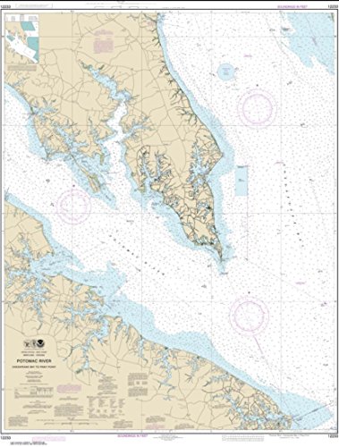
Binding : map
Brand : East View Map Link
BulletPoint : Laminated Fishing Chart
BulletPoint1 : Notice: NOAA-OCS cancelled Raster and PDF chart 12233- Potomac River Chesapeake Bay to Piney Point Edition #39 on November 16, 2022. The product will NOT meet U. S. and international carriage requirements for commercial vessels defined in SOLAS Chapter V Regulation 19.2.1.
BulletPoint2 : Printed on PaperTyger, a lightweight, tear-resistant, water-resistant paper with a smooth matte paper feel.
BulletPoint3 : Printed by East View Geospatial. Map scale: 1:40,000. Map size (inches): 118 x 89.
BulletPoint4 : Pre-production finishing for superior quality.
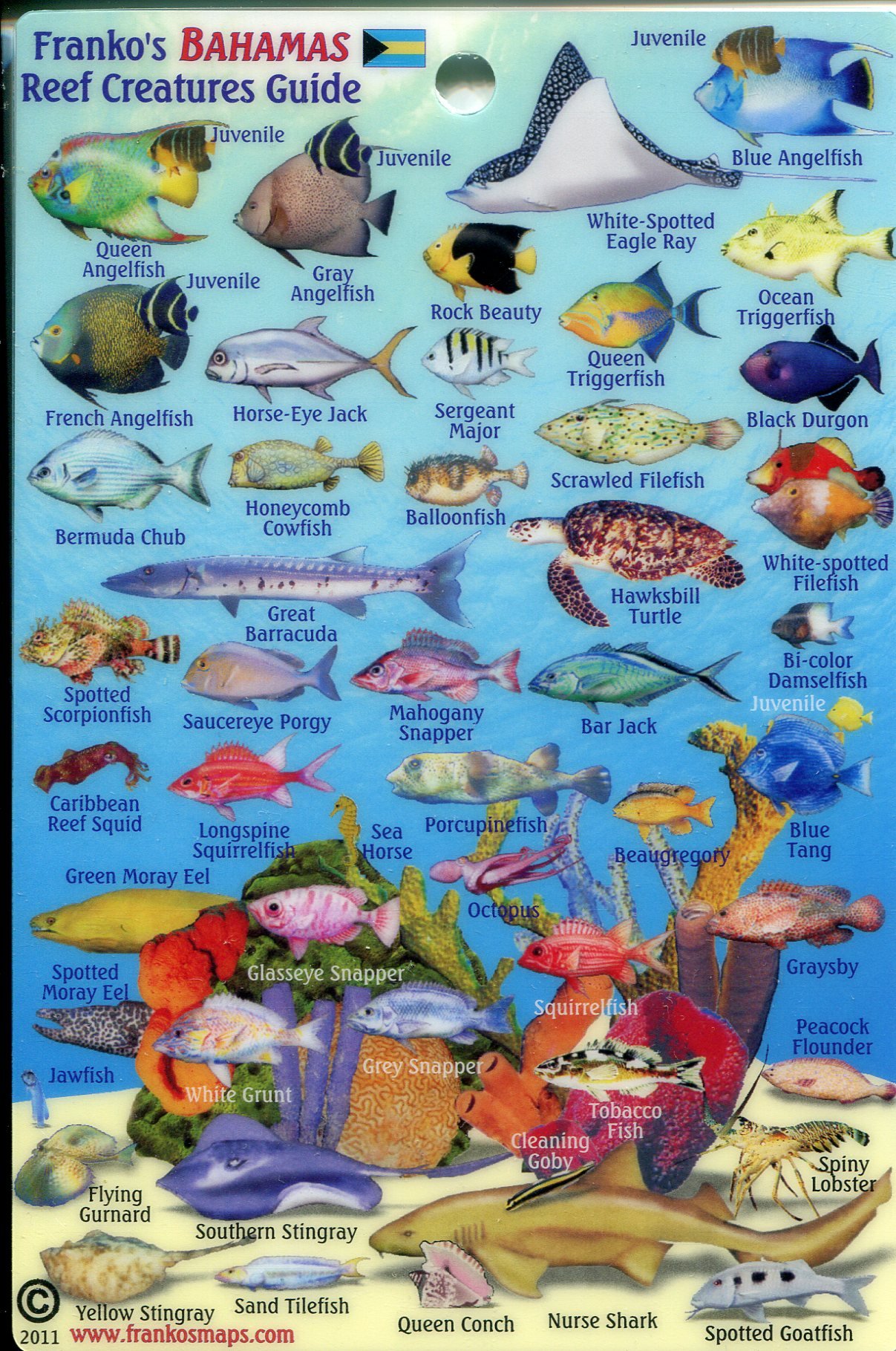
BulletPoint5 : COMPREHENSIVE VISUAL AID - Offers clear, accurate depictions of Bahamas reef creatures, aiding both novice and experienced divers in marine life recognition.
Color : full color
ExternallyAssignedProductIdentifier : 4301180031805
ExternallyAssignedProductIdentifier1 : 740399008965
ExternallyAssignedProductIdentifier2 : 0740399008965
ExternallyAssignedProductIdentifier3 : 00740399008965
Format : folded_map
ImportDesignation : Made in USA
IncludedComponents : fishing-charts-and-maps
ItemName : NOAA Chart 12233-Potomac River Chesapeake Bay to Piney Point - Water-Resistant - by East View Geospatial
ItemPackageDimensions_Height : 36.9 centimeters
ItemPackageDimensions_Length : 0.5 centimeters
ItemPackageDimensions_Width : 17 centimeters
ItemPackageQuantity : 1
ItemShape : Rectangle
ItemTypeKeyword : fishing-charts-and-maps
Language : english
Manufacturer : East View Geospatial
MapScale : 1:24,000
MapType : Nautical
Material : Polypropylene
ModelName : 89F
ModelNumber : 89F
NumberOfItems : 1
PaperFinish : watercolor
PaperFinish1 : matte
PaperFinish2 : smooth
PaperSize : 118 x 89 inches
PartNumber : NOAA12233
ProductDescription : East View Geospatial (EVG) is a certified NOAA and NGA print on demand printer. Our nautical charts are printed using high resolution images. All NOAA nautical charts are printed by East View Geospatial.
NOAA-OCS cancelled this Raster and PDF chart. The product will NOT meet U.S. and international carriage requirements for commercial vessels defined in SOLAS Chapter V Regulation 19.2.1.
ProductSiteLaunchDate : 2019-06-11T19:49:51.432Z
PublicationDate : 2017-08-01T00:00:00.000-07:00
ShipsGlobally : 1
Size : 19.5" x 26.5"
Style : Cape
SupplierDeclaredDgHzRegulation : not_applicable
SupplierDeclaredHasProductIdentifierExemption : 1
UnspscCode : 55101500