
Cart 2 india
In2Cart
Rs. 0
0


Product Information
Specification
Binding : map
Brand : NOAA
BulletPoint : Laminated Fishing Chart
BulletPoint1 : Printed on high quality waterproof and tear-resistant material
BulletPoint2 : Always printed on demand using the most recent NOAA data
BulletPoint3 : Prepared to be display quality. Arrives rolled, not folded.
BulletPoint4 : These waterproof charts satisfy USCG CARRIAGE REQUIREMENTS
BulletPoint5 : Handy 8.5 x 11 inch size. Page count varies depending on the chart.
Color : Multicolor
ExternallyAssignedProductIdentifier1 : 0612524299329
ExternallyAssignedProductIdentifier2 : 612524299329
Format : folded_map
Hazmat : auto-grounding
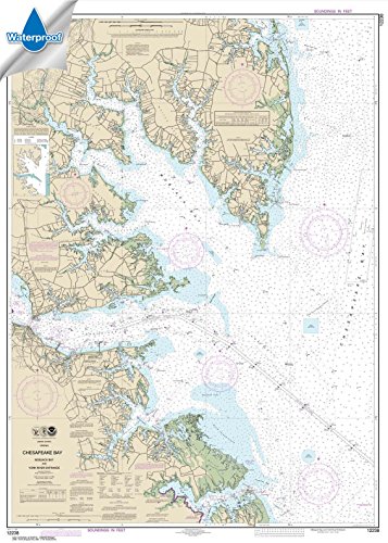
ItemName : NOAA Chart 12238: Chesapeake Bay Mobjack Bay and York River Entrance 33.6 x 47.1 (Waterproof)
ItemPackageQuantity : 1
ItemTypeKeyword : fishing-charts-and-maps
Language : english
Language1 : english
Language2 : english
Language3 : english
Language4 : english
Language5 : english
Manufacturer : Paradise Cay Publications
MapScale : 1:24,000
MapType1 : Freshwater
MapType2 : Freshwater
MapType3 : Freshwater
MapType4 : Freshwater
MapType5 : Freshwater
NumberOfItems : 1
PaperSize : 12x55 inches
PartNumber : A312
ProductDescription : Completed in 1937, Lake Buchanan is the northern most lake within the Highlands Chain of lakes. An impoundment of the Lower Colorado River, the lake is approximately 22,335 surface acres in size and boasts a boasts robust populations of striped and white bass. Under-rated populations of largemouth bass and Guadalupe bass also exist. Rounding out the fishing opportunities are good populations of channel catfish, flathead catfish and blue catfish. Featured Species: Striped Bass, White Bass, Largemouth Bass, Guadalup Bass, Blue Catfish, Channel Catfish and Flathead Catfish Map Features: Lake Profile Fishery Information Fishing Tips and Techniques Over55 Fishing Points of Interest with GPS 31Marked Fishing Locations 12Access Locations 11 Referential Waypoints All new FHS Cartography and Look Featured Species: Striped Bass, White Bass, Largemouth Bass, Guadalup Bass, Blue Catfish, Channel Catfish and Flathead Catfish Map Features: Lake Profile Fishery Information Fishing Tips and Techniques Over55 Fishing Points of Interest with GPS 31Marked Fishing Locations 12Access Locations 11 Referential Waypoints All new FHS Cartography and Look
ProductSiteLaunchDate : 2014-07-30T23:37:14.727Z
PublicationDate : 2017-06-30T00:00:00.000-07:00
Size : 19.5" x 26.5"
Style : Traditional
SupplierDeclaredDgHzRegulation1 : not_applicable
SupplierDeclaredDgHzRegulation2 : not_applicable
SupplierDeclaredDgHzRegulation3 : not_applicable
SupplierDeclaredDgHzRegulation4 : not_applicable
SupplierDeclaredDgHzRegulation5 : not_applicable
UnspscCode : 55101500