
Cart 2 india
In2Cart
Rs. 0
0


Product Information
Specification
Binding : apparel
Brand : Waterproof Charts
BulletPoint1 : Two Sided
BulletPoint2 : Foldable
BulletPoint3 : Tear Resistant Synthetic Paper (Hop-Syn) Two Sided 5 PP Tree Friendly
BulletPoint4 : Expertly researched, color coded, marked fishing areas included and boat accesses clearly marked
BulletPoint5 : Expertly researched, color coded, marked fishing areas included and boat accesses clearly marked
ExternallyAssignedProductIdentifier1 : 740399007869
ExternallyAssignedProductIdentifier2 : 0740399007869
ImportDesignation : Made in USA
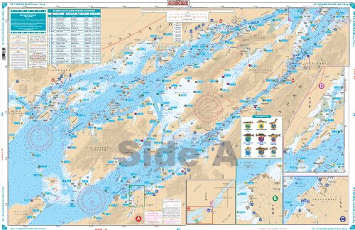
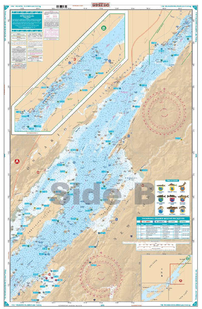
ItemName : Waterproof Charts, Lake Fishing, 78F The Thousand Islands
ItemPackageDimensions_Height : 32.4 centimeters
ItemPackageDimensions_Length : 0.2 centimeters
ItemPackageDimensions_Width : 16.7 centimeters
ItemPackageQuantity : 1
ItemShape : Rectangle
ItemTypeKeyword : fishing-charts-and-maps
Language : english
Manufacturer : Waterproof Charts
MapType : Fishing
Material : Polypropylene
ModelNumber : 78F
NumberOfItems : 1
NumberOfPieces : 1
PaperFinish : coated
PaperSize : Letter
PartNumber : 78F
ProductDescription : This LARGE PRINT Chart details all of the Major Fishing Areas and pinpoints dozens of specific areas for the major species caught in the area. (Large and Smallmouth Bass, Yellow Perch, Walleye, Muskie, Northern Pike, Channel Catfish, Muskie, Bullhead, Sunfish). Many areas have GPS positions. Marsh areas are also identified. Marinas are listed as well as popular Boat Ramps.Starting at Wolfe & Howe Islands, coverage is east to and including Brockville & Morristown. Information from 3 NOAA Charts: 14772, 14774 & 14773. This is one chart to have if you want to catch fish in this area! This Chart is 25" X 38" and folded to 7"X14". WGS84-World Mercator Datum.
ProductSiteLaunchDate : 2013-03-29T01:38:22.964Z
Size : Small Format
Style : Modern
UnitCount : 1
UnspscCode : 60101700