
Cart 2 india
In2Cart
Rs. 0
0


Product Information
Specification
Binding : miscellaneous
Brand : Waterproof Charts
BulletPoint : 12" x 18"
BulletPoint1 : Easy to Read
BulletPoint2 : Standard Navigation
BulletPoint3 : Waterproof and Tear Resistant Paper
BulletPoint4 : Printed on two sides - 2 charts in 1: Larger Area of Coverage
BulletPoint5 : Charts are Compiled From Several NOAA Charts & Local Information
Color : full color
ExternallyAssignedProductIdentifier1 : 740399009306
ExternallyAssignedProductIdentifier2 : 0740399009306
ExternallyAssignedProductIdentifier3 : 00740399009306
ImportDesignation : Made in USA
IncludedComponents : fishing-charts-and-maps
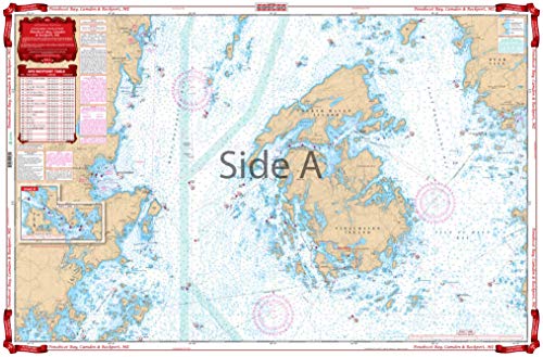
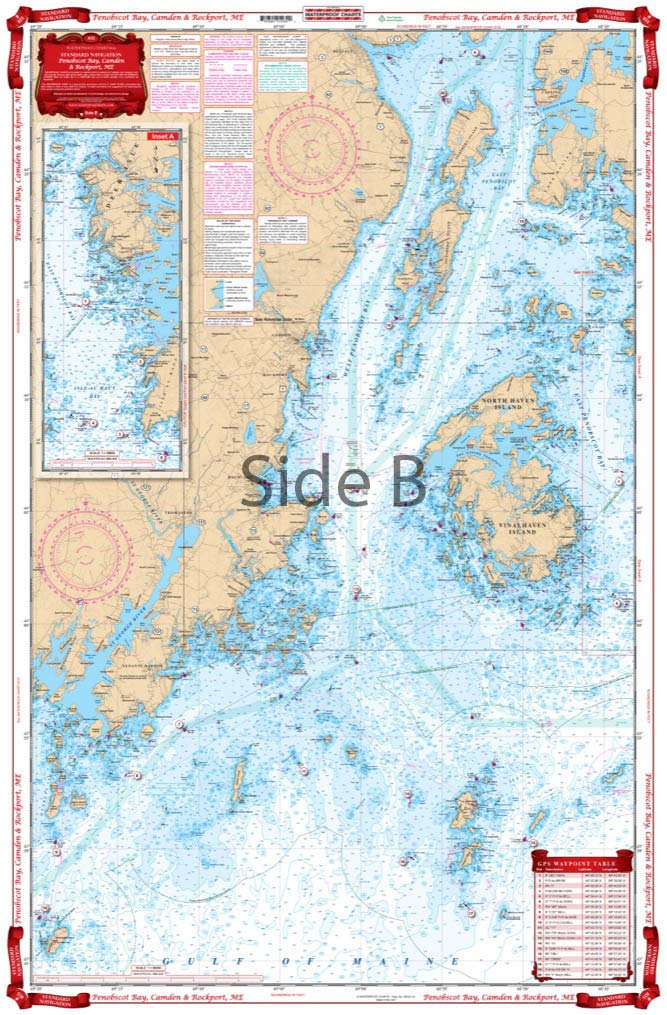
ItemName : Waterproof Charts, Standard Navigation, 103 Penobscot Bay, Camden and Rockport, ME, Easy-to-Read, Waterproof Paper, Tear Resistant, Printed on Two Sides, 2 Charts in 1, NOAA Charts
ItemPackageDimensions_Height : 68.58 centimeters
ItemPackageDimensions_Length : 7.62 centimeters
ItemPackageDimensions_Width : 7.62 centimeters
ItemPackageQuantity : 1
ItemShape : Rectangle
ItemTypeKeyword : fishing-charts-and-maps
Manufacturer : Waterproof Charts
MapType : Navigational
Material : Polypropylene
ModelName : 93
ModelNumber : 93
NumberOfItems : 1
PaperFinish1 : matte
PaperFinish2 : smooth
PaperSize : 109 x 77 inches
PartNumber : 103
Pattern : Solid
ProductDescription : Both coastal and detail coverage of this popular cruising area. On one side is overall coverage from Monhegan to Manticus Islands and north to Castine. Reverse side covers Vinalhaven and Rockland Rockport and Camden in detail with inset for Carvers Harbor. 43 GPS Waypoints make it easy to program your unit. Brighter yellow land is easy to read and bigger place names are easy to find. Information from NOAA Chart #13302 and #13305. Hey Maine boaters! We’ve got the coastal nautical chart you need in your boating bag. Both coastal and detailed coverage are included for this popular cruising area. On one side is overall coverage from Monhegan to Manticus Islands and north to Castine. The reverse side of this essential navigation map covers Vinalhaven and Rockland Rockport and Camden Maine in detail with a special inset just for Carvers Harbor. The 43 GPS Waypoints make it easy to program your GPS unit for useful spots in the area. The vibrant colors and large fonts make these marine charts easy to read while out on the water. These same colors make this navigation chart excellent for framing. Information from NOAA Charts #13302 and #13305. Nautical Chart is 25″ X 38″. WGS84 – World Mercator Datum.
ProductSiteLaunchDate : 2008-09-18T10:11:19.000-00:00
ShipsGlobally : 1
Size : 12" X 18"
Style : BookletChart
SupplierDeclaredDgHzRegulation : not_applicable
UnspscCode : 60101700