
Cart 2 india
In2Cart
Rs. 0
0


Product Information
Specification
Brand : Outdoor Dog Supply
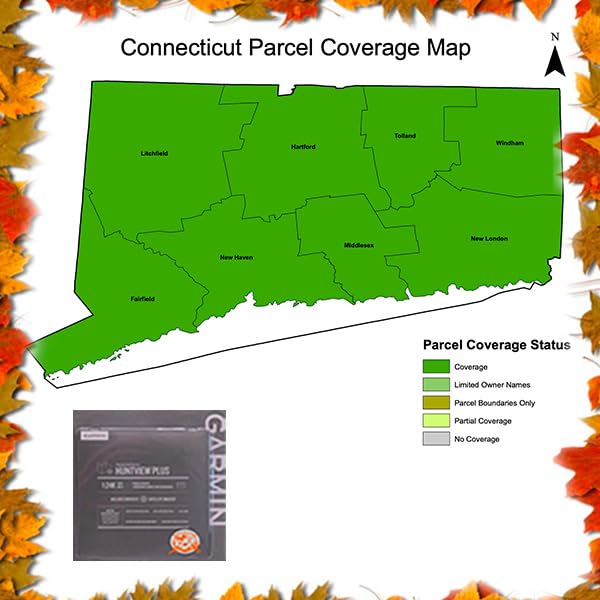
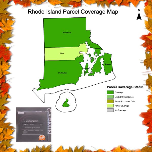
BulletPoint : Updated 2023/2024 maps Only for Massachusetts, Connecticut, and Rhode Island
BulletPoint1 : Height: 1.5 inches / 4.0 cm; Width: 1.5 inches / 4.0 cm; Border: Merrow - overlock
BulletPoint10 : Points of interest including lodging, restaurants, gas stations & garages
BulletPoint2 : Durable Black VeIcro/Hook and Loop Backing
BulletPoint3 : Embroidery Quality Guaranteed by Patchion LTD
BulletPoint4 : Need to Customise This Patch? Contact us
BulletPoint5 : Includes motorcycles-only trails
BulletPoint6 : Includes special designation trails
BulletPoint7 : Road network
BulletPoint8 : Buildings, pylons, power lines, bridges, dams, railroads other points of reference
BulletPoint9 : Lakes, rivers, streams, wetlands, waterfalls
Color : black
CompatibleDevices : Garmin handheld GPS devices
ConnectivityProtocol : Bluetooth
ControlMethod : application
ExternallyAssignedProductIdentifier : 59061620154470
ExternallyAssignedProductIdentifier1 : 0753759334413
ExternallyAssignedProductIdentifier2 : 753759334413
GpsrSafetyAttestation : 1
HardwareInterface : micro_sdxc
HumanInterfaceInput : unknown
IncludedComponents : SD map card
ItemName : Garmin Huntview Plus, Preloaded microSD Cards with Hunting Management Units for Garmin Handheld GPS Devices, MA, CT, and RI 2024
ItemPackageDimensions_Height : 19 centimeters
ItemPackageDimensions_Length : 0.9 centimeters
ItemPackageDimensions_Width : 13.5 centimeters
ItemPackageQuantity : 1
ItemTypeKeyword : handheld-gps-units
Manufacturer : Garmin
MapType : North America
MemoryStorageCapacity : 32 GB
ModelName : Huntview Plus
ModelNumber : Huntview Plus
MountingType : Handlebar Mount
MountingType1 : Dashboard Mount
MountingType2 : Handlebar Mount
NumberOfItems : 1
NumberOfPieces : 2
OperatingSystem1 : Windows 7
OperatingSystem2 : Windows 8
OperatingSystem3 : Mac OS X Intel
PartNumber : 453
ProductDescription : Featuring exclusive BirdsEye Satellite Imagery and 1:24K scale TOPO mapping, these preloaded microSD cards offer a seamless hunting map solution for Garmin handheld GPS devices. Map data is collected from multiple sources, providing full state-by-state coverage with routable road and trail data, landowner names and boundaries for public/private land types and boundaries (BLM, National wildlife refuges, National parks, WPA, WMA), food/fuel locations and now game management zones, and more. Included BaseCamp software lets you interface your computer with your handheld device to plan your hunt, transfer waypoints, and even keep a track log so you can return to the best hunting spots or share the adventure online. The Huntview Plus now features game Management Zones. Keep track of which species of game you can hunt on what land, and where the boundaries end. Easy-to-use mapping solution for hunters and outdoorsmen – plug-in microSD card or download the mapping to a blank microSD card from home Identifies landowner names and boundaries for public/private land types and boundaries, using data from multiple sources for superior coverage and detail Digital topography equivalent to 1:24,000 scale U.S. Geological Survey maps Shows thousands of routable roads and trails with turn-by-turn navigation Includes searchable points of interest: parks, summits, geographic place names, camping areas, businesses, and more Provides Bureau of Land Management township, range and section information, plus USGS quad location Includes hunting management units – containing boundaries and multiple species (where applicable). A device software update is required to view this information and some updates are coming soon. Learn more. Compatible with BaseCamp software for managing data on your GPS and computer, trip planning, playing back routes and tracks, geotagging photos and more. Updates maps for 2023/2024
ProductSiteLaunchDate : 2023-12-19T15:27:27.409Z
SecureDigitalAssociationSpeedClass : class_2
SupplierDeclaredDgHzRegulation : not_applicable
SupportedSatelliteNavigationSystem : gps
UnspscCode : 25173100
WarrantyDescription : 30 days
WarrantyType : Limited