
Cart 2 india
In2Cart
Rs. 0
0


Product Information
Specification
BatteriesRequired : 1
Binding : pc
Brand : Garmin
BulletPoint : Weight: .
BulletPoint1 : Easy-to-use 6” chartplotter with a bright, sunlight-readable touchscreen display
BulletPoint2 : Built-in Garmin Navionics+ coastal charts with integrated Navionics data
BulletPoint3 : Built-in Wi-Fi connectivity lets you wirelessly share sonar, waypoints and routes with another ECHOMAP UHD2 chartplotter
BulletPoint4 : Wirelessly connects to your Force trolling motor to create and follow routes, navigate to waypoints, control speed, check battery life and more
BulletPoint5 : Included all-in-one HV-100 transducer delivers super-high resolution CHIRP down, side and RealVision 3D along with a high CHIRP fish-targeting channel
Color : Black
CompatibleDevices : Smartphone, Tablet
ConnectivityProtocol : Bluetooth
ConnectivityTechnology : Bluetooth
ControlMethod : touch
ExternallyAssignedProductIdentifier1 : 079324634895
ExternallyAssignedProductIdentifier2 : 0079324634895
ExternallyAssignedProductIdentifier3 : 00753759128883
ExternallyAssignedProductIdentifier4 : 0753759187026
ExternallyAssignedProductIdentifier5 : 00753759168346
Hazmat : 3
HumanInterfaceInput : unknown
ImportDesignation : Imported
IncludedComponents : gWind Transducer, Propeller installation instructions
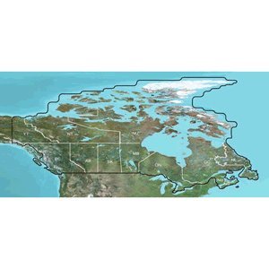
ItemName : Garmin TOPO Canada Full Coverage - MicroSD/SD
ItemPackageDimensions_Height : 1 inches
ItemPackageDimensions_Length : 4 inches
ItemPackageDimensions_Width : 4 inches
ItemPackageQuantity : 1
ItemTypeKeyword : boating-gps-units
Manufacturer : 010-C1086-00
MapType : Topographical
MapType1 : Satellite
MapType2 : Nautical
Material : Plastic
ModelName : 010-12117-20
ModelNumber : 45101
ModelYear : 2018
MountingType : Mast Mount
MountingType1 : found in image
MountingType2 : Dashboard Mount
NumberOfItems : 1
NumberOfLithiumIonCells : 1
NumberOfLithiumMetalCells : 1
OperatingSystem : Android
PackageLevel : unit
PaperFinish : matte
PartNumber : 45101
PowerSourceType : Battery Powered
ProductDescription : TOPO Canada - microSD/SDOutdoor enthusiasts: we've mapped every hill and valley for your next great adventure. This mapping product covers the finer details of the outdoors, including terrain contours, topo elevations, summits, routable roads and trails, rivers, lakes and geographical :Provides detailed topographic maps, based on digital 1:250,000 and 1:50,000 scale NTS dataContains hydrographic features, including coastlines, lake/river shorelines, wetlands and perennial and seasonal streamsIncludes searchable points of interests, such as parks, campgrounds, scenic lookouts and picnic sitesOffers terrain contour and elevation information, along with summits, peaks and geographic pointsContains routable roads, trails and highways in metropolitan and rural areas so getting to your destination is easyDisplays national, state, local parks, forests and wilderness areasIncludes BaseCamp software (DVD Only) for managing data on your GPS and computer, playing back routes and tracks, geotagging photos and moreCoverage:Features digital topographic maps for all of Canada.
ProductSiteLaunchDate : 2012-07-05T19:40:03.090Z
Size : One Size
SportType : Boat sports
StreetDate : 2023-02-10T00:00:01Z
Style : Garmin Navionics+ U.S. Coastal
SupplierDeclaredDgHzRegulation : not_applicable
SupplierDeclaredDgHzRegulation1 : not_applicable
SupplierDeclaredDgHzRegulation2 : not_applicable
SupplierDeclaredDgHzRegulation3 : not_applicable
SupplierDeclaredDgHzRegulation4 : not_applicable
SupplierDeclaredDgHzRegulation5 : not_applicable
SupportedSatelliteNavigationSystem : gps
TouchScreenType : Capacitive
UnspscCode : 43000000
WarrantyDescription : Warranty