
Cart 2 india
In2Cart
Rs. 0
0


Product Information
Specification
Brand : MAPTECH
BulletPoint : Great Product
BulletPoint1 : Comprehensive Chart Coverage
BulletPoint2 : Surveys from multiple Private and Government Sources
BulletPoint3 : Satellite Images from Digtal Globe
BulletPoint4 : Marinas, Amchorages, Local Knowledge
BulletPoint5 : Select up to 10 color-shaded target depth ranges to scope out the best fishing spots
Color : Black
ConnectivityTechnology : Bluetooth
ControlMethod : touch
ExternallyAssignedProductIdentifier1 : 0743611047
ExternallyAssignedProductIdentifier2 : 9780743611046
FabricType : Plastic
GpsrSafetyAttestation : 1
HasColorScreen : 1
ImportDesignation : Made in the USA
IncludedComponents : Garmin 010-C1289-00 Navionics Vision+ microSD and 1-Year Subscription - US North Lakes, Rivers, and Coastal Marine Charts
ItemName : MAPTECH®ChartKit The Bahamas to Crooked Island Passage Region 9 7th Edition
ItemPackageDimensions_Height : 0.762 centimeters
ItemPackageDimensions_Length : 55.88 centimeters
ItemPackageDimensions_Width : 45.72 centimeters
ItemPackageQuantity : 1
ItemShape : Rectangular
ItemTypeKeyword : boating-gps-units
Manufacturer : Richardsons' Maptech
MapType : North America
Material : Paper
ModelName : MAPTECH® ChartKit
ModelNumber : R09 07
MountingType : Panel Mount
NumberOfBoxes : 1
NumberOfItems : 1
PackageLevel : unit
PartNumber : R09-07
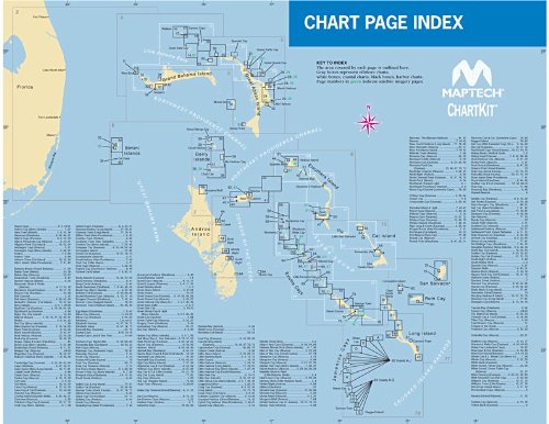
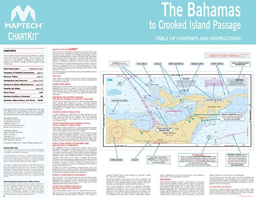
ProductDescription : The Bahamas to Crooked Isand Passage, MAPTECH ChartKit Region 9 7th Edition contains 88 pages of full-color, detailed Navigation Chart coverage including The Abacos, Grand Bahama, Bimini, Berrys, Andros, Nassau, Eleuthera, Exumas, Little San Salvador, Cat Island, Long Island, Conception, Rum Cay, San Salvador, Jumentos & Ragged Island. Includes on Page2 a chart showing 18 Routes for crossing from Florida to various Bahaman destinations, with pre-drawn routes with distances and bearings, as well as Waypoints for the destinations.
ProductSiteLaunchDate : 2013-10-25T19:58:31.916Z
RequiredProductComplianceCertificate : California Air Review Board (CARB)
Size : 22 x 17 Inch
SportType : Fishing
Style : Garmin 010-C1289-00 Navionics Vision+ microSD and 1-Year Subscription - US North Lakes, Rivers, and Coastal Marine Charts
SupplierDeclaredDgHzRegulation : not_applicable
UnitCount : 1
UnspscCode : 60101700
WarrantyDescription : Warranty