
Cart 2 india
In2Cart
Rs. 0
0


Product Information
Specification
Binding : apparel
Brand : Navionics
BulletPoint : Great Product
BulletPoint1 : Maximize every moment of fishing when you upgrade to the unrivaled accuracy and detail of Humminbird LakeMaster mapping, which features easy-to-read contours, highlighted depth ranges, and scrollable lake lists.
BulletPoint2 : This Quebec Edition, Version 1 is loaded with contours for over 1,000 lakes within Quebec.
BulletPoint3 : Easy-to-see shading highlights shallow-water areas within an adjustable range up to 30 feet, and depth contours and shorelines can be synchronized with the actual water levels of lakes, reservoirs, and rivers.
BulletPoint4 : LakeMaster digital maps can be used with Minn Kota i-Pilot Link (sold separately), allowing you to follow a selected depth contour line to deliver precise, automatic boat control.
BulletPoint5 : LakeMaster digital maps come on a Micro SD card (with included SD card adapter) that's compatible with all GPS-equipped HELIX, SOLIX, ONIX, and ION Series models and select 600-1100 Series models.
Color : No Color
CompatibleDevices1 : Approach S12
CompatibleDevices10 : Venu Sq
CompatibleDevices11 : Venu Sq - Music Edition
CompatibleDevices2 : Approach S40
CompatibleDevices3 : Approach S40 and CT10 Bundle
CompatibleDevices4 : Approach S42
CompatibleDevices5 : Forerunner 245
CompatibleDevices6 : Forerunner 245 Music
CompatibleDevices7 : Forerunner 55
CompatibleDevices8 : Venu
CompatibleDevices9 : Venu 2 Plus
ConnectivityProtocol : Wi-Fi
ConnectivityTechnology : Wi-Fi
ControlMethod : touch
CustomerPackageType : Standard Packaging
ExternallyAssignedProductIdentifier1 : 821245991690
ExternallyAssignedProductIdentifier2 : 0821245991690
ExternallyAssignedProductIdentifier3 : 00821245991690
ExternallyAssignedProductIdentifier4 : 0753759188689
ExternallyAssignedProductIdentifier5 : 00753759188689
ExternallyAssignedProductIdentifier6 : 00753759168308
HumanInterfaceInput : keypad
ImportDesignation : Made in the USA
IncludedComponents : Great Product
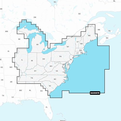
ItemName : Navionics NAUS007R - U.S. East - Navionics+
ItemPackageDimensions_Height : 14.4 centimeters
ItemPackageDimensions_Length : 2.4 centimeters
ItemPackageDimensions_Width : 10.6 centimeters
ItemPackageQuantity : 1
ItemTypeKeyword : boating-gps-units
Manufacturer : Navionics
MapScale : 1:50,000 or smaller
MapType : Satellite
Material : Plastic
ModelName : 010-C1370-30
ModelNumber : 010-C1370-30
ModelYear : 2018
MountingType : Flush Mount
MountingType1 : found in image
MountingType2 : Lake Mount
NumberOfItems : 1
PackageLevel : unit
PaperFinish : matte
PaperSize : 22 x 17 inches
PartNumber : 010-C1370-30
PowerSourceType : Battery Powered
ProductDescription : ncludes Abacos, Grand Bahama, Bimini, Berrys, Andros, Nassau, Eleuthera, Exumas, Little San Salvador, Cat Island, Long Island, Conception, Rum Cay, San Salvador, Jumentos & Ragged Island. Full-color satellite imagery, marinas, anchorages, and local knowledge. 22 X 17", 84 chart pages.
ProductSiteLaunchDate : 2022-09-13T13:45:20.744Z
Size : One Size
SportType : Sailing
Style : Garmin 010-02366-61 GPSMAP 943xsv SideVü, ClearVü and Traditional CHIRP Sonar with Mapping - 9", Navionics+
SupplierDeclaredDgHzRegulation : not_applicable
SupportedSatelliteNavigationSystem : gps
TouchScreenType : Capacitive
UnitCount : 1
UnspscCode : 41112901
WarrantyDescription : Warranty